FileFormats::GeoTIFF Class Reference
#include <GeoTIFF.h>
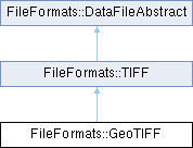
Inheritance diagram for FileFormats::GeoTIFF:

Public Member Functions | |
| GeoTIFF (const QString &fileName) | |
| Constructor. | |
| GeoTIFF (QIODevice &device) | |
| Constructor. | |
| QGeoCoordinate | bottomLeft () const |
| Geographic coordinate for corner of raster image. | |
| QGeoCoordinate | bottomRight () const |
| Geographic coordinate for corner of raster image. | |
| QString | name () const |
| Name, as specified in the GeoTIFF file. | |
| QGeoCoordinate | topLeft () const |
| Geographic coordinate for corner of raster image. | |
| QGeoCoordinate | topRight () const |
| Geographic coordinate for corner of raster image. | |
| Public Member Functions inherited from FileFormats::TIFF | |
| TIFF (const QString &fileName) | |
| Constructor. | |
| TIFF (QIODevice &device) | |
| Constructor. | |
| QMap< quint16, QVariantList > | fields () |
| TIFF data fields. | |
| QSize | rasterSize () |
| Size of the TIFF raster image. | |
| Public Member Functions inherited from FileFormats::DataFileAbstract | |
| bool | isValid () const |
| Validity check. | |
| QString | error () const |
| Error string. | |
| QStringList | warnings () const |
| Warnings. | |
Static Public Member Functions | |
| static QStringList | mimeTypes () |
| Mime type for files that can be opened by this class. | |
| Static Public Member Functions inherited from FileFormats::TIFF | |
| static QStringList | mimeTypes () |
| Mime type for files that can be opened by this class. | |
| Static Public Member Functions inherited from FileFormats::DataFileAbstract | |
| static QSharedPointer< QFile > | openFileURL (const QString &fileName) |
| Open file, file URL or Android content URL. | |
Detailed Description
GeoTIFF support.
This class reads GeoTIFF files, as specified here: https://gis-lab.info/docs/geotiff-1.8.2.pdf
It extracts bounding box coordinates, as well as the name of the file. This class does not read the raster data. GeoTIFF is a huge and complex standard, and this class is definitively not able to read all possible valid GeoTIFF files. We restrict ourselves to files that appear in real-world aviation.
Constructor & Destructor Documentation
◆ GeoTIFF() [1/2]
| FileFormats::GeoTIFF::GeoTIFF | ( | const QString & | fileName | ) |
◆ GeoTIFF() [2/2]
| FileFormats::GeoTIFF::GeoTIFF | ( | QIODevice & | device | ) |
Member Function Documentation
◆ bottomLeft()
|
inlinenodiscard |
◆ bottomRight()
|
inlinenodiscard |
◆ mimeTypes()
|
inlinestaticnodiscard |
◆ name()
|
inlinenodiscard |
◆ topLeft()
|
inlinenodiscard |
◆ topRight()
|
inlinenodiscard |
The documentation for this class was generated from the following file:
- /home/runner/work/enroute/enroute/src/fileFormats/GeoTIFF.h
Generated by